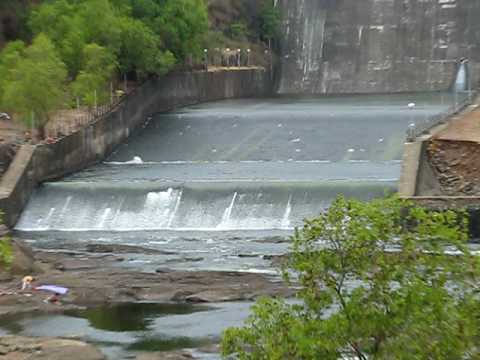
CHANDOLI DAM ONE OF THE
Possibly the world's first soil dam. Work was started in 1976. Used for agricultural purposes only although a small electricity generation plant also runs beside. The dam is built on the Varna river which forms the boundary between Sangli and Kolhapur districts. There are bare plateaus and rocks as well as caves in the park. Water is an important environmental resource. Chandoli National Park receives heavy rainfall up to 4764 mm per annum. Even though, the park area faces the problem of scarcity of water mostly during the summer season. The temporary springs and streams must be converted into temporary or seasonal ponds by a construction of an embankment across the flow. Under the habitat improvement, development of new springs and new water bodies should be included (Thakur et al. 1993). In the present investigation, it was observed that there was a construction of nala bundings in certain areas which is insufficient.
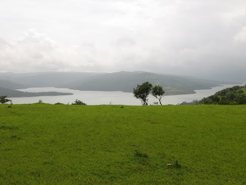
BACK WATERS
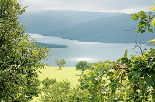
The back waters for the dam form the refuge for the Chandoli National Park. This dam is very old. The villages near the dam are aarala, kokrud, shedgewadi.The route is like karad-shedgewadi-arala-chandoli.it is nearly 50 kms away from karad.iIt is small one dam.there is a sanctuary spot. SC The Chandoli National Park is near the Chandoli Dam and is surrounded by Ratnagiri District, Satara District and Kolahapur District. The Park envelopes the Sahyadiri Range in the Western Ghats and protects the perennial streams and water holes as well as the Vasant Sagar Reservoir. The altitude of the park ranges from 589 to 1044 metres above mean sea level. There are many streams and the major river that flows through the Park is Warna River.
CHANDOLI DAM
The demand of water is increasing along with increasing population and type of use (Porter, 1978). The received rainwater is drained away very fast by streams and rivers and some water percolates in top soil and rocks. So the small streams and rivulets of hilly area become dry during summer and create shortage of water to wildlife and people (Basak et al. 1986). So the management of water resource in the park area is need of for the conservation of park. 255 The terrain of entire protected area is undulating with different dimensions so the distribution and availability of water is uneven in this park. The 80% of total protected area is effectively covered with water facility and remaining 20% of the park area in higher reaches in the region of Gave, Chandoli khurd, Male, Patharpunj, Rundiv, and Jawali were facing the problem of water source for local people, domestic animals and wild animals. The construction of ponds and tanks are best means to store the surface water for domestic purpose. People have to use surface water during monsoon and subsurface water during post-monsoon period (Pitchaiah, 1991).
WATCHTOWER
Vamdevan & Vasu (1986) suggested the following water management techniques for the Western Ghats. Bench terracing, nala bunding, nala training, contour staggered trenches, micro-irrigation including drip irrigation using flexible PVC pipes and bamboos, mini sprinklers, subsoil injector and indigenous drip irrigation using earthen pots as well as diaphragm wall, hydraulic rams, stormwater harvest warping, bordered gardens, development of micro-catchments, eco-mulching cum irrigation for plantation crops and use of windbreaks and shelter. Giles and Wunderlich (1981) have suggested the similar techniques for the water resource management.